Geosciences Popularization
编辑: 小编 时间:2023-07-03 18:51:28 浏览次数:
Inner Structure of the Earth
Through seismologic technology, scientists have found out that the Earth consists of several concentric and spherical layers. Based on its chemical and physical features, the Earth is further dividedinnerwards into three parts, crust, mantle and core. The crust has an uneven thickness, thinner in ocean part and thicker in land area, with a mean about 33 km. The crust is mainly composed of silicate rocks. The layer below the crust is the mantle, which is about 2,800 km thick. The mantle is further divided into the upper and lower mantles. The former is about 1,000 km thick and mainly made up of eclogite, while the latter is some 1,800 km thick and is guessed to be composed mostly of oxides of iron, magnesium and other metals. In the mantle, about 60 ~400 km below the Earth’s surface, there exists a plastic layer called asthenosphere. The convection of theasthenosphere can cause the crustal movement. The solid part above the asthenosphere, including the upper mantle and the crust, is called lithosphere. Below the mantle, the inner part of the Earth is the core. The radius of the core is 3,468 km. The core can also be divided into two parts, outer and inner cores. The out core is about 3,100 km thick. Inferably, the out core could be in fusing-liquid status while inner core in solid status.
Surface of the Earth
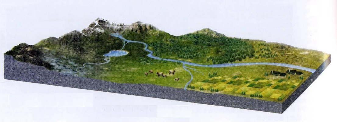
The outermost layer of the Earth is the crust, which is the place we are living on. The crust is composed of rock and soil coverage. Most of the crust’s surfaces are covered by oceans, whereas lakes and rivers are usually distributed in the depression parts of the lands. In cold area, water accumulates and appears in the form of glacier. Besides, in a certain depth beneath the land surface, there also exists water, which is called underground water. All these various forms of water consist of the hydrosphere. Above the lithosphere and hydrosphere, the whole Earth is surrounded by the atmosphere. The lithosphere, hydrosphere and atmosphere are separated but interacted with each other. Consequently, there are areas on the Earth, which have mineral materials, air and water. Plus suitable temperature conditions, the areas have become the places for organisms to live and thus is called biosphere. Human beings are the most active component of the biosphere.
How do geologists trace the geological history?
The human history can be traced through literature records and archaeological studies on cultural relics. How do geologists trace the geological history? The geologists have found that the there are a number of layered rocks, called strata in geology, covering the Earth’s surface. This is really a complete book recording the evolutionary history of the Earth for several hundred million years. The various rocks of the strata are similar to literature records of the book and fossils just like cultural relics. It is such literature records and cultural relics that can be used by geologists to understand the evolutionary history of the Earth through scientific and technological methods and the idea that Today is the Key to Understand Yesterday.Present evidence indicates that the Earth wasformedabout 4.6 billion years ago. However, the geologists can only understand its evolutionary history of the last 600 million years. The history of the rest stages is still based on various guesses. In spite of appearing 3 billion years ago, organisms were in a very low form for a long time and the fossils of the organisms may have almostdestroyed due to metamorphism on the fossil-bearing rocks. It was until 5.7 million years ago(mya)that a number of organisms in higher forms appeared and were preserved as fossils in non-metamorphic rocks. The fossils have provided us many reliable materials for understanding the Earth’s history,Based on the evolutional stages of the fossils preserved in sedimentary rocks, geologists can judge depositional sequences of the fossil-bearing rocks. The ages of the rocks can be further determined by isotope technique. Combining the fossil method with isotope technique, the evolutionary history of the Earth’s crust can be understood more accurately. In 1881, International Geological Society approved the Stratigraphical Division Schema. Later on, the schema has been modified, consummated and become a complete geochronologic chart used today as a basis for dividing the Earth’s history.
Geologic Time scale
The Main Events in the Earth’s History
Plate Tectonics
The Earth is moving constantly and so are the materials inside the Earth. The constant movement of the materials inside the Earth causes the sinking, uplifting, faulting and folding of the crust. Geologists have different views on the mechanism of the crustal movement. Plate tectonics is a theory that believes the Earth's lithosphere is made up of several plates and the plates are moved by the convection of the asthenosphere in the upper mantle.
The lithosphere is composed of seven major plates and many minor ones. The seven major plates are: Eurasian Plate, Pacific Plate, African Plate, North American Plate, South American Plate, Australian-Indian Plate and Antarctic Plate. The tectonic system, formed by the interactions among the plates, is called plate tectonics.
Geological Process
Geological Process: Force of Modifying the Earth’s Surface It is geological process that results in continuous changes and developments of the components, structures and surface of the Earth’s crust. The energies from inner Earth have made the Earth’s crust in active. The energies come from many sources like those produced by the splitting of the radioelements inside the Earth or those produced by speed variations of the Earth’s self-rotation. The movement of the Earth’s crust is global and pays a dominant role in modifying the form of the Earth’s surface. Such a geological process resulting from the endogenic forces of the Earth is called the endogenic geologic process, which has not only made the inner Earth’s structures more complicated but also enhanced the relief differences of the Earth’s surface. Under a long-term stress of the Earth’s crust, the hard rocks can be twisted and broken up. Strong press can cause the uplift of the rocks and thus the formation of mountains. The pull force, on the other hand, can result in the depression of land and thus the formation of the lowlands, lakes and oceans.
The appearances of mountains and waters we see today have already undergone modification by the sun, air, water, organism and other natural forces. These forces have worn away the projected portions of the Earth’s surfaces and moved the so-produced debris to deposit in the depressed low areas. This exogenetic force-induced process, which is unrelated to the Earth, is referred to as the exogenic geologic process, which, in contrast with endogenic geologic process, reduced the relief differences of the Earth’s surfaces.Geological processes can not only modify the form of the Earth’s surface but also cause the continuous changes in components and structure of the Earth’s crust.
Classification Schema of Geological Process
Magmatism
The magma within deep Earth has extremely high temperature and is under very high pressure. However, the fault zones developed in Earth’s crust can cause the lowering down of local pressure. As a result, the magma will move up to the upper part of the crust along the fault zones. This is called Intrusive Magmatism. If the magma further spills over the ground surface, a volcanic activity happens.
Intrusive Rock
The produced rock of intrusive magmatism is intrusive rock. The rock was usually produced in a depth several meters to more than ten meters below the Earth’s surface and thus has coarse crystals because of slow cooling down during the crystallization. The crystals can be easily recognized with naked eyes. The intrusive rock can expose on the ground if the Earth uplifts and its above overlaid rocks are eroded away. The chemical components of the intrusive rock are dominated by silicates. According to the content of silica in the rock from less to more, the intrusive rock can be divided into four groups: ultrabasic, basic, intermediate and acid rocks. The main intrusive rock type in the Yong’anGeopark is acid rock and then basic rock.
The Alkali-feldspar Miarolitic Granite
In the coastal area of Fujian, the miarolitic granite is distributed in a NE direction, with a length of 500 km and a width from 60 km to 90 km. It has near 100 rock bodies. The Alkali-feldspar miarolitic granite is a specialhypabyssal granite with deep source, recording the continental-crust stretching. The main intrusive period of the miarolitic granite was in the late Early Cretaceous to early Late Cretaceous. The chemical composition of the rock is characterized by over-acid, rich-alkali, and poor-femic, with SiO2>76%, Na2O+K2O>8.3%, Na2O>3.75%, FeO+Fe2O3+MgO <2.5%. According to the results of many research projects, it can be inferred that the mantle magmatic composition can make up 65.3% to 76.3% of the miarolitic granite, the maximum formation depth of the rock ranges from 1,000 m to 2,000 m, and the temperature of the main magma crystallization phase is between 893℃ and 1,043℃.Alkali-feldspar miarolite is characterized by deep source, shallow formation, and completely differentiated composition. During the crystallization of this over-acid, rich-alkali and poor-femic magma at a shallow depth, the contained gases were unable to escape from the magma due to high viscosity of the magma. This resulted in the formation of many cavities, which further developed to form the special miarolitic cavity structure in the later crystallization phase.
Volcanic Activity and Volcano Rock
When the rising magma from the deep earth moves up along the fault zone and the pressure of the magma is greater than that of the shallow place near the earth’s surface, the magma will seep out, which results in the volcanic eruption.This is the volcanic activity. The rock formed by the activity is called volcanic rock. Although there are various volcanic rocks, they have a common feature, i.e. finely grained (fine-grained crystalline). Sometimes, the flow structure or vesicular structure can be observed. The volcanic rock is valuable for studying the components and structureof the deep Earth because the volcanic rock originates from the deep Earth and hence bears lots of information of that part.
Tephra(Pyroclast)
(pyroclast)was the fragment ejected to the air, possessed a certain degree of sorting when it dropped, that is, the coarser tephra near to crater, the finer away from crater. The tephra may divide into several types according to the size and shape, such as volcanic ash, lapillus (volcanic gravel), volcanic block, and volcanic bomband so on. After consolidation it becomes pyroclastic rock.
(Ash)Volcanicash
The rock and magma are broken into fine particles in volcanic eruption, to formvolcanic ash. It is composed of particlesof rock, mineral and volcanic glass, with a diameter less than 2 mm. Volcanic ashisquite hard and insoluble in water, different fromcigarette ash(Photo 3-8). The red-hotvolcanic ash ascendsrapidly with up-ward currentin volcanic eruption, will threaten the security of aviation. The volcanic ash of large-scale eruption can stay in stratosphereover a long period of time; it may produce a serious influence to the earth climate and therespiratory system of human and livestock. The drop of volcanic ash may be harmful to the people.
Tuff
Tuff is a kind of pyroclastic rock, more than half of its composition is volcanic ash, in different colours: black, violin, red, white and pale green. According the composition of pyroclast, tuff can be divided into crystal fragment tuff, vitric fragment tuff and rock fragment tuff.
Ignimbrite
During the volcanic activity, viscous and rich volatile-bearing lava moved to the crater and exploded because of a sudden decrease in pressure. This formed a hot tuff flow or pyroclastic flow, which was a suspension of particles and gases. The flow later accumulated to have formed the rock in a high temperature condition. The rock is composed of fragments of lava, crystal, plastic glassy material and ash. The glassy materials were flattened and elongated during the compaction, showing a rhyolitic structure
(Lapilli)
Lapilli is pyroclast in diameter 2 to 64 mm, “lapilli”is an Italian word in meaning of “little stone”. In addition, another lapilli is known as accretionary lapilli, also in diameter 2 to 64mm, its particularityis in orbicular shape, composed of cemented layers of fine grain volcanic ash
Volcanic Breccias
volcanic breccia is composed of the volcanic fragments with sizes ranging from 2 to 64 mm. The fragments are usually angular and the spaces between them are filled with volcanic ashes and dusts.
(Block)Volcanicblock
Volcanic block is the rock fragment with sharp edges and corners, diameter greater than64mm. Its common composition is lava cooled in early stage. The early stage lava in upper part of cone is broken into volcanic block during the explosion of volcano when the lava is in solid state; it is the reason of volcanic block with sharp edges and corners.
Volcanic Bomb
Volcanic bomb, a mass ejected from a volcano, often of molten lava having rounded or spindleforms, cooling as a mess with the diameter large than 64mm when falling down.They often accumulated near the volcano crater, or on the slope of crater cone.
Volcanic Agglomerate
The volcanic fragments with the size greater than 64 mm are called agglomeration. When the content of the agglomeration in a rock is greater than 30%, the rock is the volcanic agglomerate. The composition of the volcanic agglomerate is quite complicated and the fragments are usually angular. The cements of the rock consist of pieces of rock, glassy material and volcanic ash. Volcanic agglomerate generally distributed around the volcano routeway. The huge rock blocks in the agglomerate show the great power of the volcanic eruption.
Magma
In ordinary circumstances, magma ordinary consist of melting liquid, mineral crystallized in melting liquid, xenoliths and inclusions, as well as gas dissolved in magma. Based on the content of SiO2, magma is divided in acid (SiO2more than 65%wt), neutral (SiO2between 52%wt and 65%wt), basic(SiO2between 45%wt and 52%wt)and ultrabasic (SiO2less than 45%wt). The flow property of magma is in inverse proportion to the content of SiO2, basic lava is easy to flow, and acid lava is difficult to flow. After solidification of magma it becomes lava.
Rhyolite and Bubble Rhyolite
Rhyolite is a common type of lava. It forms from the cooling-down magma with 70~76 percent silica(SiO2), which flows from crater during volcanic eruption. This kind of magma has high viscosity. It often has a flowing-banding structure generally showing fine laminas but sometimes locally has a structure like whirlpool. Some magma may be rich in gas. The expansion of the gases can form many differently-sized bubbles(Photo 3-17). Some materials separated out from magma may deposit along the bubble walls and form stone bubbles. This stone bubble-bearing rhyolite is called bubble rhyolite.
Andesite
Andesite is a common volcanic lava, its content of SiO2varies from 52%wt to 63%wt: basaltic andesitefrom 52 % wt to 57 % wt, common andesite from 57 % wt to 63 % wt. Andesite is of gray, black, red, violin and brown colours, after alteration showing green colour, and of porphyry texture, whose phenocryst consists of plagioclase and dark minerals. Sometimes it is of blowhole (gas hole; gas pocket) structure, when the holes are full of calcite, quartz or chlorite, becomes amygdaloidal structure(Photo 3-19). Andesite is an important magma rock to compose island arc, widespread in Cenozoic Pacific rim area. The word “andesite” originates the Andes(mountain) of South American
Subvolcanic Rock (Orthophyre)
With the lowering of the eruption energy, some magma cannot reach the surface and therefore can only form a subvolcanic body in the area near the ground surface by crystallization from the cooling magma. The orthophyre in Baishuiyang River is such a kind of rock, which forms the base of the distinct flat riverbed.
Volcanic Columnar Jointing
Volcanic columnar jointing is common in base rocks like basalt but sometimes can also be observed in acid gnimbrite. The rock columns usually have 5~6 sides. It is generally believe that the columns were formed by the contraction during the slow cooling down of the hot lava flow or pyroclastic flow. The columns are always vertical to the isothermal plane that represents rock-cooling temperatures. The columnar jointing can be used to judge the attitude of the volcanic rock beds. Also, the curved direction of the column or the bubble shape in the rock can be used to decide the flowing direction of lava and the location of the volcanic crater. In the geopark, well-developed column jointing can be seen in Qipanding and on the Zhengshan-Shuangxi highway sides.
Metamorphism and Metamorphic Rock
Metamorphism is referred to the process which causes the mineral component, texture,structure and sometimes chemical composition of the original rock (sedimentary rock, magmatic rock and metamorphic rock) to have been altered due to the effect of the endogenic forces like tectonic movement, magma activity and thermal-flow change within the Earth’s crust. The resulting rock is called metamorphic rock. The metamorphic rock is usually deformed and foliated due to the orientation of the mineral constitutes in a parallel arrangement and thus has schistosity.
Tectonic Movement
Tectonic movement is the mechanical process of the Earth’s crust caused by endogenic force of the Earth. Tectonic movement can deform and displace the Earth’s crust and cause magmatism and metamorphism on rocks.
Fold
The bended rocks are called fold, which was formed under strong pressure. It can be easily recognized in layered rocks, indicating a plastic deformation once happened on the rocks.
Rock Breaking
When a rock is under a pressure strong enough to exceed the maximum limit of the rock’s elasticity, the integrity of the rock will be broken, which results in the formation of rock breaking. The types of the rock breaking include fault, joint and fracture. The displacement amount of faults is different. The small one can be only a few centimeters and the great one, on the other hand, can be several hundreds of kilometers. The fracture along which no appreciable displacement has occurred is known as the join (t Fig.
Sedimentation
Sedimentation is referred to the process in which transported materials (mud, sands and pebbles) settle down and accumulate in sequence due to the change of physical and chemical conditions of transportation medias like water, wind and glacier. In general, sedimentation can be classified into two basic types: continental and marine. While based on its depositional mechanism, sedimentation can be categorized into three types: mechanical, chemical and biologica.
Sedimentary Rock
Sedimentary rock forms on the Earth’s surface from the transportation, accumulation and consolidation of sediment (pebble, sand and clay) that is the product of wearing and erosion on native rocks (granite, volcanic rock, metamorphic rock and previously-formed sedimentary rock). Clastic rock (conglomerate, sandstone, siltstone, etc.) is the rock formed by the deposition of fragments of older rocks of source area. The fragments were mechanically broken up and transported to the depositional site by water, air or glacier(Photo 3-25). Chemical rock, such as halite and gypsum, is formed by chemical precipitation from out of a solution(Photo 3-26). Biogenetic rock (such as organic limestone and reef limestone) is composed of animal and plant remains or organic secretions(Photo 3-27). The bedding is the most characteristic structure of sedimentary rocks.
Bedding
A layering structure shown by vertical changes of rock’s properties. The change can be represented by different rock composition, grain size, texture and/or colour. The bedding is an important indicator for geologists to infer sedimentary environment during the deposition of the sediments.
Weathering
Weathering is the process of change, especially decomposition of rocks in physical or chemical ways due to exposure to the air. Factors contributing to weathering include solar radiation, water, air and organic activities. It can be classified into physical and chemical weathering. The former refers only to the breakdown of rocks and the latter to the change in chemical composition of rocks. Although different, these two weathering processes usually work together to decompose rock In addition, the biological weathering on rocks is also important. For example, the plant root can break rocks.Weathering can contribute to the formation of some of the spectacular landscapes, but can also damage the stone inscriptions and buildings.
Erosion Action
Erosion action refers to a changing progress of rock surface and its weathering product by external forces such as wind, flowing water, glacier, waves in moving state. Erosion action can be divided into mechanical and chemical erosion.
Running Water Erosion
Fluvial erosion action is the broken and saluted process of rock and soil by the action of flowing water (including rain). The running water on the slope washes the whole hill slope, to make it broken. The flowing water make the ravine and riverbed wider (lateral erosion), deeper (down-cutting effect) and longer (headward erosion). Almost all mountain and river valley we have seen result from the long period of fluvial erosion and cutting(Photo 3-36,3-37). With the increasing of river flow and its kinetic energy, or neotectonic uplifting, the erosion action of running water will be strengthened.
Geological Process of River
A river is a natural watercourse, always or periodically flowing towards lower lot along a linear trough(river bed), which might form by its own erosion. Geological process of river divided into: erosion, transportation and sedimentation..Water within a river is generally collected from precipitation through surface runoff, groundwater recharge in its reach. As erosion of running water, small rivers may become longer, deeper and wider, from ravine, rivulet, creek, brook or stream, changing to a big river.
Erosion
Erosion is the process of washout or destroying of river bed by kinetic energy of river itself. According to the forms of erosion, river erosion could be divided into: hydraulic action, abrasion, detrition and dissolution. The hydraulic action of river is referred to the direct impact of running water upon rocks; the impact force is in direct proportion to the runoff and velocity of running water. The abrasion caused mainly by the load transported in running water, it is the friction between the load and river banks or river bed that makes river course wider and deeper. Detrition is referred to the loads transported in river collide and abrade each other, became smaller et rounded. Dissolution is a process that soluble minerals in rocks of river bank or riverbed are dissolved by running water, flowing away in form of solution. For a common sense, hydraulic action and abrasion are more important. The river erosion towards the source, riverbed and side banks three directions. Headwords erosion makes the river extends to upper reaches(Photo 3-39), down-cutting erosion make it deeper, lateral erosion makes it wider
Transportation
Transportation is the movement of substances who eroded from the riverbed or valley slopes by running water. The capacity of transportation is in direct proportion to the velocity of runoff and volume of running water. There are four models of transportation: (1.) solvend in solution; (2.)fine grains of clay or silt in suspension, sailing with the stream; (3.) bigger fragment of rocks transported in saltation form, rolling up with flow occasionally. (4.) big stone and other heavy matter move only in rapid stream or flood. Most of transportation of river is the mechanical transportation of water insoluble, small part as chemical transportation of solute.
Sedimentation
Sedimentation is the tendency for particles in suspension to settle out of the fluid in which they are entrained, and come to deposit as sediment. This process often happens in situations of river slope reducing, riverbed widening, runoff decreasing or turbidity increasing. The transportation of river brings about a sorting effect: particles to deposit in sequence of the size and weight, i.e. coarse and heavy earlier, fine and light later. If sedimentation rate is too fast, the sorting will be absent
The Function of River
River is a precious and renewable natural resource(Photo 3-43). Although the total drainage area of river coversonly a tenth area of the earth, and river water is one ten-thousandth of total water resource of the earth, river is still the main water resource of human and living thing in some countries and areas. River is utilized in traffic navigation, water supply for agriculture and livestock, aquiculture and hydroelectric generation. It provides the leisure sites of visit, swimming, boating, camping, fishing and hunting. River and human civilization development are closely bound up in coordination with one another. Apart from human being, many wild living things (such as fish, shrimp, amphibian, aquatic insect and algae) live, ingest and multiplyin river. So that, river is an important protection for wild living things.
Mass Wasting
Mass wasting is the process by which the rock and regolith on the Earth's surface move downslope mainly due to the gravity force, such as landslide and collapse-induced rock fall. Mass wasting can be triggered by some factors like rainfall and earthquake. Rock usually fell along the planes of joints and fractures(Photo 3-44).Landslide and rock fall can form beautiful landscapes.However, they can also be geologic hazards, which may cause damages or loss of property and life