Geological Sites of Dayushan Island
编辑: 小编 时间:2023-07-03 18:43:50 浏览次数:
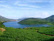
The Dayushan Island is one of the top ten most beautiful islands in China and also the biggest island in northeastern Fujian. The Dayushan Island with continuous and sinuous coastal lines, scattered beaches, glistening waves and various marine erosion scenic spots. The island is 5km in diameter and covers an area of 21.5 square kilometers. The summit of the island on the Hongjidong Mountain is 541.4 meters above sea level. Therefore, it is the highest island in Fujian. Lakes and a vast pasture lie in the centre of the island. These make the island a peculiar landscape rarely seen in the islands of southern China. There are three lakes at the altitude of 200m, named Ri (Sun), Yue (Moon) and Xing (Star).
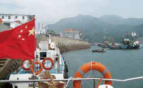
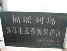
1.Mazu Dock
The Mazu Dock is the first stop when tourists visit the Yushan Island. The stele here, set up by the Ningde Government, marks that the island belongs to the Island Eco-system Protected Area.
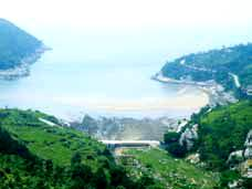
2.Dashiao Sand Beach
The sand beach is located at the brook mouth and formed by the joint effect of sea and river. The sea-eroded sediments and fluvial transportation matters are deposited on the gulf beach, forming a unique muddy sand coast landform. Here is a good place to visitors for sightseeing, boating and various activities on sand beach.
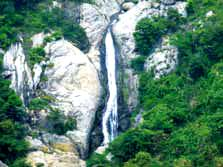
3.Bailian Waterfall
The waterfall is developed on the small brook in the mountains just behind the Dashiao Sand Beach. The water amount is variable in different seasons. Due to the abundant rainfall in the island, the waterfall is flowing all year round. The steep slope where the waterfall is developed is retreated due to the long-term backward erosion. It is only 2 or 3 minute walking distance from the sand beach to the waterfall. Standing here, you can enjoy the mixed sound of the waterfall andwave. The combination of mountain, water and sea sceneries creates a marvelous spot.
4.Jiuzhugangcao Lake
This lake is the second largest freshwater lake on the Yushan Island, developed in the depression of volcanic rocks formed by the long-term weathering. Due to the abundant rainfall and warm and humid climate, the rain water collected here and finally formed a natural lake, which is the main drinking water source in the island. The good climatic conditions and fertile volcanic rock-weathered soil make an excellent surrounding environment.
5.Camping Site
The Camping Site can provide a place to rest for tourists, with complete camping equipments. It is located at the lakeside of Datian Lake, facing a small brook. The environment is sound here, there is a spring water pouring down from the back hills. It is a good place to fishing and relaxing. Meanwhile, there is a tea garden nearby, visitors can not only enjoy the camping life, but also experience the tea-collecting pleasure.
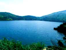
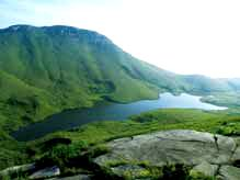
6.Datian Lake
The Datian Lake was once a gulf. After built a dam, it becomes a lake, which is the largest freshwater lake and one of the freshwater sources in the island. Surrounded by peaks, it becomes a natural water convergence site, the abundant precipitation here provides sufficient water source for the lake. Standing on the lake side, you can enjoy the clean lake water, and green-covered peaks around.
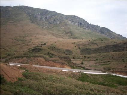
7.Sea-eroded Depression(The Mountain of Hongji Cave)
The Sea-eroded Depression is by the side of the Mountaion of Hongji Cave. It is inverted triangle-shaped depression landform. The reason of the formation is the mountain was eroded by the ancient sea before the crustal movement occurred. The depression is also a relic about the sea-eroded landform. The two scarps on the bath sides of the depression are serrated. Their length are about 50 meters and their height can be up to 6 meters. The bottom of the depression is flat, and the exit is narrow. It’s lithology is mainly granite. There are grey volcanic rocks at the top of it.
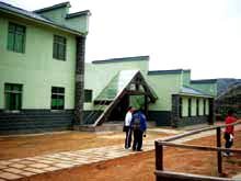
8.Tourist center
The tourist center of Yushan Island Scenic Area is the largest one in this scenic area. The Center is a two-storied building, with complete facilities, including restaurant, lounge, bathroom and toilet. It is located by the side of Datian Lake, the environment is elegant. This Center can provide basic information and a good resting place to visitors.
9.Xiaotian Lake
The Xiaotian Lake is a natural lake, covering an area of about 200 mu (one mu is roughly equal to 1/15 of a hectare). After the long-term weathering process, a depression was formed in the volcanic rocks here, the abundant rainfall collected here and finally formed a lake due to the warm and humid climate. This lake is the third largest freshwater lake in the island. The sufficient water sources and fertile volcanic rock-weathered soil have nourished a vast grassland more than ten thousand mu. This is a very unique scenery on islands of China. Looking at southwestward, you can see a sea island - Turtle-like Island only one kilometer away, and it is only 50 sea miles from Keelung Port of Taiwan in the southeastern direction.
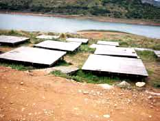
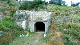
10.Relic of Martial Base
Here is a ruin of a coast defense military base. Up to now, the houses, water supply pipes and air-raid shelters are still well preserved, and these infrastructure can still be put into use. This military base is endowed with a strong sense of history and can be an excellent choice for playing real-person anti-terrorism games. At the same time, the complete infrastructure here could be a good place for camping and other activities.
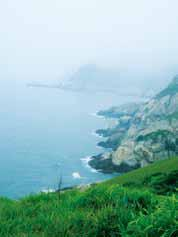
11.Gulf and Cape
A gulf is a sea which is encircled by land on three sides. In contrast, a cape is surrounded by sea on three sides. Due to the difference in lithological properties, the softer rocks will be easy to be eroded, so an arc-shaped gulf will be occurred gradually. However, the harder rocks are relatively hard to be eroded, so the rocks here will remain and protrusive to the sea, so a cape would be formed. Here we can see the two landforms at the same time.
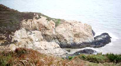
12.Sea Cliff
Sea cliff is a common sea cut landform. At the foot of the sea cliff, the coastal bedrocks are often subjected to the abrasion of sea waves, the sea caves will be formed firstly, thus the caves are expanding continuously, and collapse could be taken place, and finally, the sea cliff is formed, the coast moves backward. Some of eroded debris will become a part of coastal sediments which are transported by coastal currents.
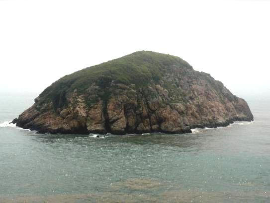
13.Small Island (Yangguwei Island)
Island is resulted from sea abrasion, belonging to a kind of seaeroded landforms. Due to the difference of rock coast, the sea wave will make continuous erosion and destruction on coast rocks, the differential erosion will form the protruding seaeroded rocks. When the sea-eroded rocks are separated from the coast, so the island is formed.