Geological Sites of Baiyunshan
编辑: 小编 时间:2023-07-03 18:34:05 浏览次数:
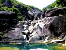
Numerous potholes, flow-erosional grooves and troughs, and vertical arc-shaped grooves are developed in river courses or cliff walls by the two river banks in the Jiulongdong in the Baiyunshan. The pothole-dominated water erosion heritage is widely and densely distributed with big size and changeable shapes. The abundant quantity, various types, big size, systematical development and well preservation make the landform extremely rare. Therefore, the landforms are worthwhile visit and study. They display the river erosion microlandform and most beautiful scenery in the geopark.
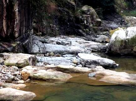
1.Rock Step and Deep Pond
The alkali-feldspar miarolitic granite has NE-extending joints and fissures. The rock step in front of you was formed by erosion along the joints and fissures in the bedrock of the riverbed. There are flow erosion-generated potholes and troughs developed on the step. A deep pool occurs in the bedrock of the riverbed below the step, which is the erosion product of the water falling from the step. Rock step, fallingwater, and deep pool make it attracting scenery composed of these river erosion-generated landforms.
2.Waterfall-like rock
The weathering has loosed the cliff wall composed of alkalifeldspar miarolitic granite. The down-moving of rainwater along cliff wall has washed away the loosed rock fragments from the cliff wall. With time goes by, this kind of water erosion has left many densely distributed U-shaped rocky grooves. It looks, from distance, just like a pouring-down waterfall.
3.Intrusive Contact Relationship Between Alkali-feldspar Miarolitic Granite and Volcanic Rock
Why can these two totally differently-colored rocks exist in the same place in the river valley? This is because the place is the contact position between two different rocks. The dark colored rock is a volcanic rock formed about 120 million yeas ago(Early Cretaceous)during a volcanic eruption event, while the light colored rock is an intrusive rock, alkalifeldspar miarolitic granite, formed about 90 million years ago(Late Cretaceous). Here you can see the latter intrudes into the former, showing an intrusive contact relationship of the two rocks.
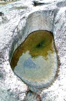
4.Footprint-like Pothole
The Footprint of Nature is really a basin-like pothole, vividly similar with a footprint. It was formed by flow erosion and sand-pebble wearing on the riverbed.
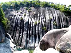
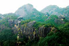
5.Rock Wall Group
After long stress of the Earth’s crust, a group of NEE-extending joints and fissures, which are parallel to each other, has developed in the alkali-feldspar miarolitic granite in the Chan Stream area. Weathering, water erosion, and gravitational collapse have converted the granite into a series of rock walls standing one by one, forming a majestic sight. There are water erosion-generated grooves, either shallow or deep, densely developed on the wall surface, just like hanging groups of waterfalls.
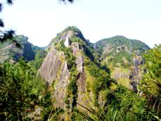
6.Alkali-feldspar Miarolitic Granite Landform and Volcanic Landform
Why do the east and west sides of the Chan Stream have totally different landforms? The reason is that the two sides have different lithology. The landform of the east side belongs to volcanic mountain landform, while the west is granite mountain landform. The granite is stronger than the volcanic rock in resisting weathering and therefore has steeper mountain body.
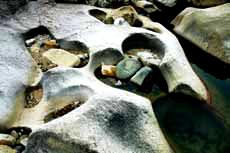
7.Heart-like Potholes
The linked potholes are formed by the perforation of nearby potholes because of the enlargement and deepening of the potholes. These linked potholes have separated openings but linked inner walls. When the inner walls are completely worn away, the linked potholes will become the assembled pothole.
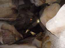
8.Jiulongdong Shelter
The Jiulongdong Sheltere is a maze-like cave formed by the accumulation of huge rock blocks on the riverbed. The blocks were fallen from two side cliffs of the river due to gravitational collapse. Inside the cave, you can see differently-shaped potholes on the riverbed or rolling stones and may be astonished by nature’s great power. Are you also aware of the truth that softness (water) can overcome strength (rock).
9.Linked Potholes
Due to flow erosion and sand/pebble wearing, the deepening and enlargement of several nearby potholes has resulted in the thinning and penetration of the walls between the potholes. This eventually formed linked potholes with separated openings but linked inner walls. The Linked Potholes is a so-formed linked pothole comprising three inner-linked potholes.
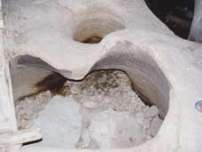
10.Yaochi Pond
This is originally a jar-like pothole formed on the steep bank of the river, with one side close to the riverbed. Therefore, the out wall of the pothole was suffered the side erosion of the river, while the inner wall was eroded by eddy flow. This finally resulted in the penetration of the river-facing sidewall. With the enlargement of the penetrated hole, the jar-like pothole gradually converted to the wall-penetrated pothole.
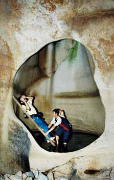
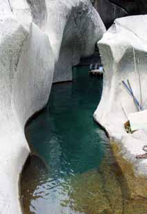
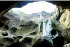
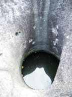
11.Feitian Well
Feitian Well is a giant wall-penetrated pothole formed by the lateral erosion of flowing water and vortex currents. It is 38 meters deep and 23 meters in diameter. Multiple layers of niche-like pits occur at various heights on the well wall, formed by vortex lateral erosion of the pothole wall by running water during different periods. Several subsidiary potholes are scattered on the well bottom, formed by the waterfall cascading down from the cave roof and flowing across the well floor, which eroded the bedrock together during different seasons. Standing within it feels as if you are at the bottom of a well. With its enormous scale and protracted history of erosion, Feitian Well has become a classic example of this type of geological landscape and holds a significant value for comparative research at home and abroad.
12.Flow Erosion-generated Groove and Potholes
The weathering has loosed the cliff wall composed of alkali-feldspar miarolitic granite. The down-moving of rainwater along cliff wall has washed away the loosed rock fragments from the cliff wall. With time goes by, this kind of water erosion has left many alternately distributed U-shaped rocky grooves and curved ridges on the cliff wall.

13.Gourd-like Pond
There were several nearby potholes distributed on the bedrocks of the riverbed along current direction. The river erosion further caused the lowering of the front and back walls of the potholes and made them connected like linked beads. The final penetration of the front and back walls has converted the beaded potholes to a sidewall-connected trough with curved, S-shaped sidewalls.