Geological Sites of Yuanyangxi
编辑: 小编 时间:2023-07-03 18:29:02 浏览次数:
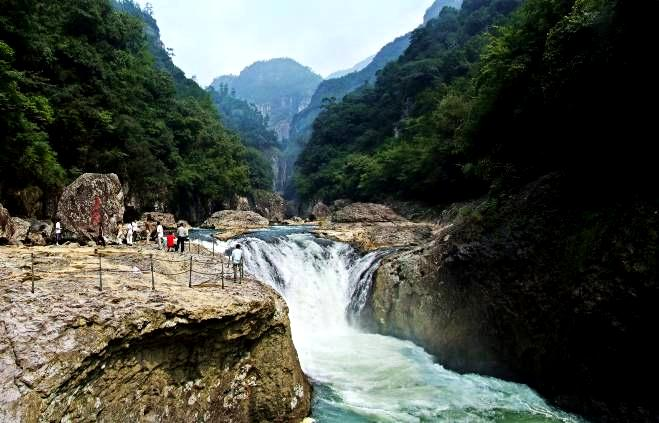
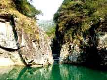
The Yuanyangxi deep-cutting canyon is developed in volcanic rocks and controlled by the NW-extending faults. The canyon has a total length of 18km and a free fall height of over 300 meters. The width of the canyon is changeable. Some can be several tens of meters, but some are less than 2 meters. The cliff walls are straight and steep, waterfalls are falling from height, the stream is sinuous, and pools appear frequently. Therefore, this canyon scenery is an integration of stream, waterfall, pool, peak, rock, cave and forest, quiet but majestic.
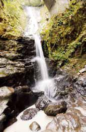
1.Trumpet-like Waterfall
The speaker waterfall is about 20 meters high and 5 meters wide at the bottom. How is the Trumpet-like Waterfall formed? The welded tuffs grow serried joints. Under the flow erosion, the rocks on the top of the cliff were cut into conic cliff. And the water falls down towards all sides along the conic cliff, just like a standing louder-speaker, so it is named “speaker waterfall”
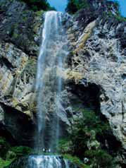
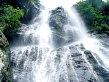
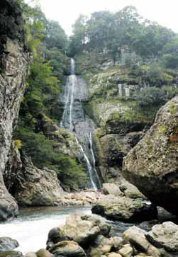
2.Baizhangji Waterfall
How is the majestic hundred waterfall formed? Under the effect of crust stress, the volcanic rocks here grow two nearly perpendicular joints in the direction of north-east and north-west. Undergoing the flow erosion, the rocks collapse down in the dense joints. And it formed the round valley with the width of about 100 meters. The Yiyang stream was cut into cliff-bed, and the water falls into the bottom from the top of the cliff like a jumping dragon. The hundred waterfall is consists of two-grade waterfalls which is about 150 meters high, and about 10 meters wide. And it is the beautiful scenery in the Baishuiyang national geopark.
3.Queqiao Waterfall
This is one of the Yiyang waterfall series. It is a typical two-layer waterfall, about 20 meters high and 5 meters wide. The waterfall is so names because there is a bridge over the waterfall。
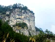
4.Big White Rock (Biyi peak)
The Big White Rock standing on the bank of the mandarin duck stream is a cluster of cliff landscape of volcanic, which consists several stone castles and stone stelaes. These stone castles and the stone stelaes stand so close that the big white rock looks like a couple of sweeties. So it is also called “Biyi peak”. The cliff of Big white rock is magnificent with the height of about 150 meters, and wide about 100 meters. The sequence of volcanic sediment and flow structure on the cliff can be clearly seen. And it is also a nature section to observe the volcanic eruption and sediment.
5.Qiandieji Waterfall
The Qiandieji Waterfall is the last level of the Baizhangji Waterfall in the Yuanyang Stream. It is about 100m high and 5m wide. The water is pouring down form the cliff that was formed by NW oriented faults, and spreads as a fan, forming a majestic fan-like waterfall.
6.Xiaohukou Waterfall
How is the splendid Xiaohukou Waterfall formed? This place is situated between the two group fractures in the direction of northeast and north-west. Here, the riverbed was cut into cliff-bed by the fracture with the height of more than 10 meters. In the cliff, the riverbed was eroded deeply by the running water tracing to the source. The upriver stream flowed into the deep and narrow riverway, and formed waterfall there. This is a beautiful landscape of waterfall as “thousand miles waves in a pot” in mandarin duck stream.
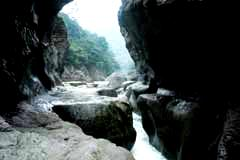
7.Xiaowuxia Ravine
The ravine is 1.5 meters wide in the gap, the cliffs on both sides are about 20 meters high. The torrents of mandarin duck stream is rushing into the Weng swag from the gap.Xiaowuxia Ravine is formed by stream erosion along the fracture of 40 ° in northeast direction. In the entrance to Weng swag, it formed the cliff and falling water. After long-terms erosion, the riverbed was cut deeply and then formed the deep swag.
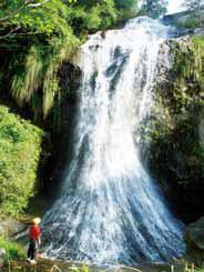
8.Fairy Waterfall
Located on the right side of the Yuanyang Stream, by the Changtanwei, the waterfall is some 100meters high and 3 meters wide. This is a four-level waterfall. The falling of the water from the cliff is so mild that you may feel like fairies coming down from heaven, and hence the name.
9.The Wavy Cliff of Immortal Banquet Ravine
The lateral erosion of the river makes the riverbed in a "S" shape along the horizontal direction. When the crust uplifted, it formed the new river quay because of the vertical erosion. In different periods, the river construction, water volume, and rock quality of riverbed are different, so the lateral erosion is different. As a result the cliff eroded forms a waving "S"shape on the vertical and horizontal direction.
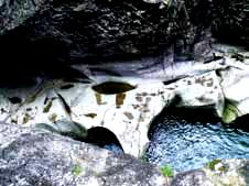
10.Water Erosion Platform
The vertivcal and lateral erosion of the river change the elevation and shape of the riverbed gradually. During the diastrophism stable time, the current eroded riverbed along the nearly horizontal bedding and joints slowly. And it formed the level riverbed. After the crust uplifted, it formed the new riverbed because of the vertical erosion of the river, and the original riverbed formed the present level water erosion platform.
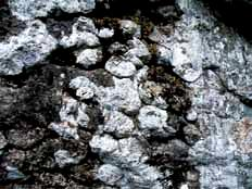
11.Erosion Grooves on Bedrock Platform
How were the Erosion grooves on bedrock platform formed? The rocks of the riverbed are different in lithology. The long-term erosion and wearing by the river-carried sands and pebbles on the rocks can produce concaved pits. The further enlargement and development of the pits finally formed these grooves with various types. The long axis of some shuttle-like grooves can indicate the direction of the current.
12.Volcanic Bomb
Volcanic Bomb, a mass ejected from a volcano, often of molten lava having rounded or spindle forms, cooling as a mess with the diameter large than 64mm when falling down. They often accumulated near the volcano crater, or on the slope of crater cone.
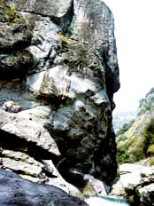
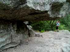
13.Tiger Mouth Rock (Pictographic Rock)
How is the Tiger Mouth Rock (Pictographic Rock) embedded in the cliff formed? It is a groove along the volcanic rock bed, formed by the weathering, running water erosion and gravity collapse along the nearly horizontal bedding and joints. The groove extends to north-east, and is about 30 meters long, 1.5 - 3 meters high and 0.5 - 3 meters deep. The top of the groove inclines towards north-west, and the bottom is straight. Standing on the Tiger mouth rock and looking around, you can see all the beautiful scene of mandarin duck valley.
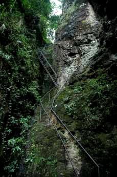
14.Lover's Ridge
If large scale vertical fissure and joint zones exist in the volcanic rocks, later water flow can erode and cut deeply through the rocks along the fissures and joints. This can form V-shaped valley with straight steep walls and uneven base. The Qingling here is a steep V-shaped valley with more than 1,200 steps. Climbing up with your lover, you can feel very romantic and exciting.
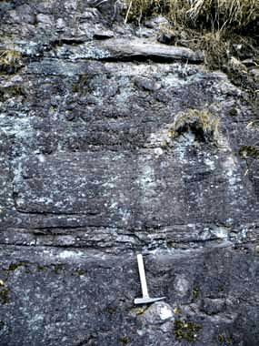
15.Rhythm of Volcanic Eruption
The Rhythm of Volcanic Eruption is shown by a series of regular changes in the composites of erupted volcanic materials, eruption intensity, and volcanic active manners. Here you can clearly see regularly-repeated appearance of rhyolite, agglomerate, ignimbrite, and bubbled rhyolite on the cliff surface, showing the rhythm of the volcanic eruption at that time.