


General Introduction to the Ningde Global Geopark
编辑: 小编 时间:2023-03-16 13:49:53 浏览次数:
The Ningde Global Geopark is located in northeastern Fujian Province, composed of Baishuiyang, Taimushan and Baiyunshan three scenic areas, covering an area of 2,660.34 km2 . It takes the characteristics of the geo-heritages of late Mesozoic granite and volcanic rock, modern river erosion landform, as well as coast and island landforms, is a large comprehensive geopark in abundant cultural landscape and favorable eco-environment.
The geopark lies in hilly land of Southeast China,the feature of total topography is northwest high and southeast low, the mountain range trends towards NE or NNE direction controlled by the structures, such as Jiufengshan and Taimushan ranges, the highest peak Dongshanding in 1,479 m above sea level. High hills situate in coastal area extending to the seashore always. The coastline here is quite twisty, where develops the mudflats at intertidal area. The islands spread all over along the coast(Fig. 1-1)
Situated in Southeast China coastal area, the geopark is featured by its subtropical ocean monsoon climate. It is the mixture of numerous climates such as mountain climate and valley climate. It is characterized by rainy spring and hot summer, sunlight and warmth of mutual benefit in winter and autumn. It is noted for its abundant quantity of heat, plentiful rainfall, distinct four seasons and remarkable feature of ocean monsoon climate. It is also featured by its large temperature difference between coastal areas and hinter land and diversity of its climates.
Geoscience baedeker to the Ningde Global Geopark
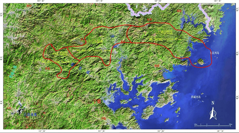
Fig. 1-1 The LANDSAT image of The Ningde Global Geopark
The annual average temperature is 18.8℃ in the coastal areas (The hottest temperature is 28.6℃ in July and the coldest temperature is 8.9℃ in January). The annual average temperature is 15℃ in the mountains of the interior (The hottest temperature is 24.4℃ in July and the coldest temperature is 5.2℃ in January. The extreme hottest temperature is 43.2 degrees, while the coldest one is -9.8℃). Frost free period ranges from 290 to 310 days in coastal areas, from 230 to 240 days in mountainous areas. Its annual average bright sunshine duration is between 1700 hours and 1900 hours. Total amount of annual sunshine radiation ranges from 4134 to 4480 MJ/m2 .
Average annual precipitation in this area increases gradually from coastal areas to mountainous ones. Its average annual precipitation amounts to over 1600 mm. Its average annual relative humidity is between 78% and 83%, and mountainous areas are more humid than coastal areas. Disastrous climate are common occurrence, such as typhoon, storm, drought, low temperature and unbroken spell of wet weather.
There two airports both in Fuzhou south of the geopark and north in Wenzhou, the scenic areas is about one to three hour car journey from the airports.The expressways henyang-Haikou and Ningde-Wuyishan, high-speed railway Shanghai-Shenzhen come through the Ningde district, have the exits or station in Taimushan, Baishuiyang and Baiyunshan scenic areas. It is known as the “golden waterway” of Saiqi to Xiabaishi villages of Fu’an city, its navigation has been opened up to Fuzhou,Xiamen, Shanghai, Qingdao and Guangzhou cities.The highways are traffic facilities predominantly inside the geopark; its network is clear between the scenic areas, convenient to reach.
All three scenic areas situate in the middle part of the Mesozoic magmatic belt in southeast China,that is a typical area of the active continental marginal zone of the Pacific rim.The late Jurassic to early Cretaceous dacite-rhyolite and igneous rocks are widespread in the geopark.The NE striking faults,NW and NEE orient faults constitute the framework structure.furthermore, they are located all in the mountain area in eastern Fujian in neo-tectonic period due to massif uplift, where develops landscape of river erosion (Fig.1-2).
There are large-scale satellite-form Yiyang caldera,Baiyunshan caldera and Bijiashan dome-shaped volcano,whose volcanic type, evolution history and bi-model volcanic rocks assemblage is typical and represent for the rock in continental margin Southeast China(Photo 1-1)
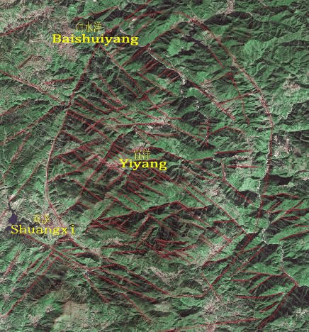
Photo 1-1 LANDSAT image of Yiyang area
Miarolitic granite is a special type of deep-source hypabyssal granite,as the magma record during the tensile-stretching of the continental crust. Taimushan and Zhuzhou granite intrusions are typical miarolitic granites, with complete rock units; it means the clear magma evolutionary process.
The peak cluster and rocky egg landforms in Taimushan miarolitic granite are best representatives of this type of landform in Southeast China hilly land (Photo1-2).
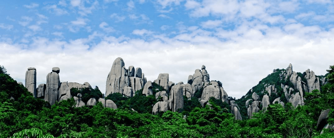
Photo 1-2 The peak cluster and rocky egg landforms in Taimushan
There are many river erosion gorges or canyons in the geopark, lots of river erosion landforms reserved there.
The Yuanyangxi (Mandarin Duck brook)is a scarce gorge, with a group of perfect water landscapes and favorable eco-environment (Photo1-3). The Longtingxi is a scare meandering brook deep-cutting gorge too, seldom seen in other area
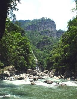
Photo 1-3 Yuanyangxi gorge
Bedrock-formed flat riverbed of the Baishuiyang brook is an unusual wide flat ground under shallow water (Photo 1-4).
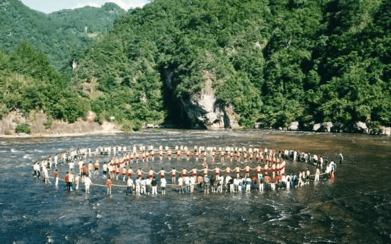
Photo 1-4 Bedrock-formed flat riverbed of the Baishuiyang
There are various types of potholes and trenches along the Chanxi and Longtingxi brooks, in great number and giant volume, demonstrating the complete evolutionary process of the potholes (Photo 1-5).
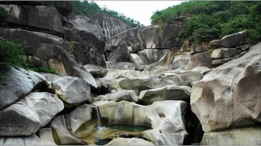
Photo 1-5 The potholes in Canxi Brook
The coastal zones and bays are continuous winding at the Taimu Mountain, with the pretty sand beaches and marine-abrasion landforms. The Yushan island is one of the top ten most beautiful islands in China, highest island in Fujian Province, the fresh water lakes and ten-thousand mu (about two thousand acres) grassland on the island are peculiar and fancy landscapes famous in Southeast China(Photo 1-6).
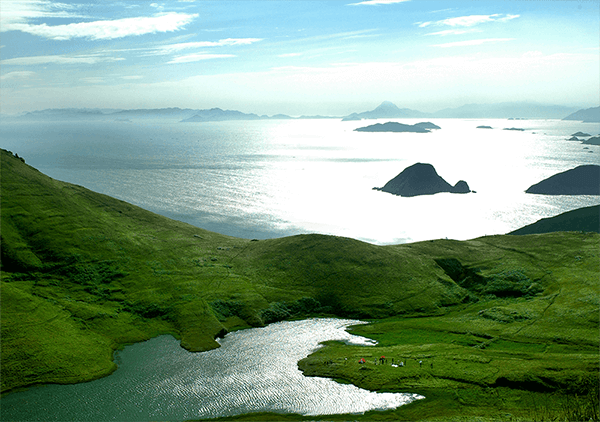
Photo 1-6 bird's-eye view of Big Yushan Island
Ningde area enjoys a long history, a rich cultural background and well-provided cultural resource; hence it boasts a relatively high value of aesthetical appreciation, history and culture.
Ningde is the region where the SHE nationality lives in compact communities, enjoys an original folk custom and culture.
Fu’an and Fuding is “Town of Tea in China”,“Panyong congou” red tea won a golden medal in the 1915 Panama Pacific International Exposition, same as “The Chinese Maotai liquor”. Taimu Mountain was the rare treasure tea since Ming Dynasty (about 500 years ago).
Pingnan is “Town of Corridor Bridge in China”, this kind of bridge is the integration of bridge, corridor, pavilion and temple, unique in the world, to build up only use wooden tenon and mortise joint need not any iron nail.
The ancient residential house in east Fujian area is unusual in constructing style, their window, door, dougong(bucket arch, a system of brackets inserted between the top of a column and a crossbeam)and corbel(hanger), produced with the care and precision of a sculptor, elegant horizontal inscribed board and wall decorations, simple and unsophisticated stone and brick carving, demonstrating the superb skills of ancient craftsman.